Selden's Map of China
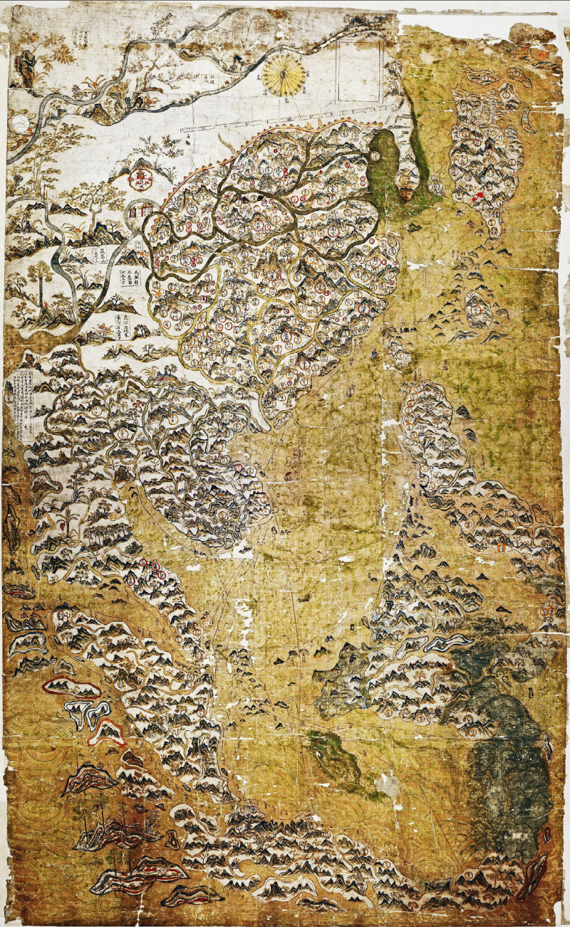
Early maps are always fascinating; the Selden map of China of 1608 is of particular value and interest. It was revolutionary as it covered not just China but most of south-east Asia – from the River Ganges to Japan and from the Black Dragon River down to Java. It represents the first fusion of eastern and western cartography.
Research into the map is the sole subject of Timothy Brook ➚'s excellent book ‘Map of China ➚’ and this article is a summary of his careful research of the topic. Timothy Brook worked with the great sinologist Joseph Needham when a young researcher.

John Selden ➚ (1584-1654) was an English scholar of great abilities and when he died the ‘Selden Map’ was a specific bequest he made to the rapidly growing Bodleian Library ➚ in Oxford. It was Selden who became involved in the important debate about the sovereignty of the seas that had great importance in years to come. It was his rival the Dutch scholar Hugo Grotius ➚ (1583-1645) aka ‘Hugo de Groot’, equally gifted, who contended that the open seas should be accessible to all nations and not ‘owned’ by any one country.
The early 17th century was the time when European powers were building rival trading empires. Columbus's voyages of the previous century had discovered new lands full of treasure that were being very profitably plundered. The Treaty of Tordesillas ➚ (1494) had divided the whole world between the two power hungry Iberian rivals. Broadly speaking Spain gained the Americas while Portugal gained Brazil and south-eastern Asia. The Protestant states (principally the Dutch and English at that time) did not feel anyway restricted by this agreement that carved up the world between the two top Catholic nations. They looked for trading opportunities anywhere they could find them and maps were key to this endeavor.
As far back as 1614 the English East India Company (EIC) had been looking to build trading links with East Asia. As China trade was closed to all but the Portuguese, particular importance was put on Japan, because in Japan there were Chinese traders who were keen to help open up trade between China and Europe. This trade went through Chinese merchants rather than directly through government officials.
Early attempts to break into the China trade by the EIC proved ineffective. When Captain John Saris ➚ returned in December 1614 it was rumored that his ship was full of Eastern treasures and luxuries. In fact Saris had only really managed to bring back some erotic paintings and prints from Japan. Competition with the Dutch to set up trade was intense and underhand tactics were often used. The brothers Li Dan and Li Huayu from Quanzhou were keen to create this lucrative link between England and China. The EIC put up considerable money to oil the wheels but the Lis prevaricated and no trade ever came from the investment. However out of this venture came a person who came to fame when the Manchus invaded in 1644. Li Dan took on a Catholic convert, Zheng Zilong, as a young protégé (and/or lover). Zheng Zilong later had a son Zheng Chenggong better known as Koxinga the leader of the last remnant of Ming resistance on the island of Taiwan.
The conquering Manchus had as little interest in the surrounding seas as the later Ming Emperors, they were people of the northern plains and foreign contacts by sea were seen of little interest or value. They left the trade to the local Chinese along the southern coast until matters got out of hand in the 19th century. Their policy was to restrict trade and not to engage with foreign nations.
All this made maps of south-eastern Asia in short supply and extremely valuable. Owning such maps was a risky business. Many consider the possession of maps as evidence of intent to spy and owners had to be careful to avoid arrest. Many maps of Ming dynasty China were destroyed during the Manchu conquest of 1644. Possession of anything pertaining to the Ming (especially maps) was considered treasonous and so many useful maps were destroyed.
The Selden map is revolutionary in its depiction of China. Older, traditional maps had shown the country as a square as that was the world view – China was the world and it had a regular layout with barbarian nations as thin margins along its four edges. The square land shape was believed to be surrounded on all sides by four seas. Perhaps an ancient description of a ‘sea of sands’ may explain the sea forming its northern border. The Selden Map gives good evidence for a shift in this world view. Careful analysis of the Chinese place names in China have shown that the content of an older map was copied into the space created by a more accurate coastal outline that had been surveyed by mariners.
The South China Sea was considered a very dangerous area – full of shoals that would wreck any boat that came too close – unless they had a map and a skilled pilot to guide them. The area was avoided at all costs and ships stuck to well known sea routes to either side of the perilous islands.
A revolutionary map
All maps of large areas have to tackle the problem of mapping a spherical world onto a flat surface. The Mercator projection was relatively new (invented 1569) and was gradually gaining acceptance. For mariners the use of rhumb lines (lines of constant bearing) was of most use and often seen on mariner's maps.
The main innovation of the Selden map is that it concentrates on the sea not the land. It was based on accurate ‘rutter’ chart measurements where the length and compass direction of individual segments of voyages are combined together into a network to form a complete map. It was of course the far earlier Chinese invention of an accurate compass that made all of this possible.
For the period from 1608 to 1650 the Selden map was the most accurate in the world for the whole south-eastern Asian area and of immense value to sea traders as it enabled them to plot safe and fast sea voyages to China, Japan and Indonesia.
Because all the Chinese place-names were written in Chinese characters, the map was impossible to decipher in Britain where the understanding of characters was only just beginning. It was the arrival of the first native Chinese to Britain that made further interpretation possible. ‘Michael’ Shen Fuzong was a Chinese Christian convert brought to Europe. He spent about six weeks at Oxford in 1687 helping Thomas Hyde ➚ ‘decipher’ the many books in Chinese already collected there. This included the Selden map on which Shen wrote marginal notes on translation for Hyde.

Modern times
The Selden map of the South China Sea from over 400 years ago casts a light on the current competing claims for sovereignty by five nations over this area. It was when Britain ‘ruled the waves’ that the basis for today’s ‘laws of the sea’ was established. The law simply states that any ship is free to navigate without hindrance outside of territorial waters.
The limit of territorial waters was set as the longest conceivable cannon shot at the time – for centuries this was three miles but in 1982 was extended to 12 nautical miles. There seems to be acceptance that the open sea should be free for all nations to roam over so the claims of sovereignty for the South China Sea boil down to whether islands and shoals are sovereign territory and so all have a 12 mile radius of territorial waters surrounding them. There is also an argument for sovereignty to be established if islands have been economically developed.
The Chinese claim to the South China Sea is based on the fact that the islands are named on old maps going back as far back as the Tang dynasty over a thousand years ago. This claim was rejected by an International panel in 2016 that rules on such matters. The international definition of sovereignty requires stronger grounds than just a mention on a map; there has to be proof of long-term historical control. The islands have to have been either permanently settled or commercially exploited. Neither of these criteria hold true for the Paracel or Spratley Islands. They are tiny and have no sources of fresh water and have only been inhabited briefly for people collecting turtle eggs and guano. It looks like the Chinese government will not accept the decision, and there is some grounds for grievance as China was not part of the negotiations when the ‘laws of the sea’ were originally drawn up. However if the Chinese claim based on map evidence was upheld then Britain, because it was the first nation to put a name to them on maps, would be able to lay claim to thousands of islands dotted all over the world. Indeed many of the individual islands in the South China Sea are still known by the names given by British mariners.